California Rain Brings Both Relief, Flooding

Look at 12z Precipitable water charts for the storm Approaching California

26th the system is weak and south of the feature in the gulf of Alaska. There is no connection the area around Hawaii, where PWS are below normal


following day ( yesterday) pws way below normal storm starting to take shape west of US coast


this morning


west of California still no connection to Hawaii. System origin from the westnorthwest


So we are now growing pineapples in the gulf of Alaska. The reason PWS increase off California was due to the deepening well to the north, not this pulling moisture out of places where Pineapples grow. There are not even any isobars that make it that far south
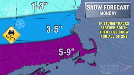
First-Look Accumulation Map

First-Look Accumulation Map

Disclaimer: This entire forecast is based on a storm track that is close enough to Southern New England to bring steady snow. Our main concern with the forecast is that the storm tracks farther south than currently projected, and takes the steadiest snow with it. In that case, Southern New England would be on the northern (lighter) edge of the storm.
We are looking at a storm that starts after midnight and before dawn on Monday. It will most likely be an issue for the Monday morning commute because the snow will have an easier time sticking to the pavement before dawn. Snow is likely all day Monday. The temperature will be in the dropping through the 20s and may reach the teens late in the day. With such cold temperatures, and snow already on the ground, the snow would continue to accumulate during the day. The storm will likely wind down by midnight, so it will not last quite as long as we originally expected. We’ll be watching the computer model trends and evolution of the system which is reaching California Friday morning. The storm is still three days away, and we will nail the forecast down over the weekend – hopefully on Saturday.

Long Range New England Weather 2-26-14

Potential big snowstorm Sunday night through Tuesday of next week. We could see some light snow on Sunday, but the storm isn’t expected to get going until late Sunday night with several inches on the ground by 7am Monday morning. The details of Monday/Tuesday are tough to pinpoint right now, but the potential is there for 6 to 12 inch snow totals across all of SNE. The storm might actually come in 2 parts. The first part Sunday night through Monday and the second part on Tuesday.

Snow to Soon Return With Cold Air in Midwest, East

As we move into next week, the pattern will be ripe for snow storms along the east coast. colder air will be pressing south from Canada as we mov into late Sunday and early Monday. At the same time, energy will be squeezing through the boundary area between the colder air to the north and the warmer air to the south. This combine with a cold front that will stall just to the sou of New England will allow moisture to form along it. This moisture will then push into New England and the mid Atlantic states giving a couple inches if snow. This event does not look big at this time, however, it should serve as a precursor to the type of vents we could be seeing as we move through the week. After this. Opulent inches Monday, Wednesday looks to send a large piece of energy our way. If the trough digs a little further south, it could be a very large storm. Presently with the energy involved, it could already be an easy chance at 4-8 inches of new snow into New England. We will keep you up to date with the latest!

(euro control says snow takes control again over the ne)