Good Evening!
Here are the short term and long term forecasts.
Short Term: A low pressure centered over the central Plains will cause a batch of showers to move through the northern plains, with a chance for severe weather in the warm sector across the central Plains. The warm front extends across the nation to the east coast, and showers will ride along it into tonight. First batch is moving through the Northeast now, and another coming through the Great Lakes. Overnight the rains showers should continue to move eastward with some new rain showers near the gulf coast. Tomorrow will be much of the same, the low will still be in the Northern Plains, leading to another severe threat for tomorrow. The warm front will continually work northward through the day bringing with it a well needed rush of warm air and calming weather for the Eastern US.
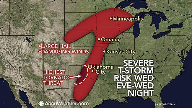
Long Term: A pretty active patter will set up across the nation heading into the weekend period. For tomorrow, a cold front will shift eastward across the central Plains with severe weather possible from the gulf coast all the way to Minnesota along the front. The highest coverage of storms should be near the area of low pressure across Iowa and Minnesota, but any storm that develops will be capable of producing very large hail and damaging winds. The front will sag southward and stall over the Ohio Valley by Friday into Saturday, with low chances of severe weather both days across the lower Mississippi Valley into the Tennessee valley. Storms could work their way into the Northeast this weekend as warmer air surges northward with this system. Looking farther out in time, it looks like some significantly warm air may affect all of the Northeast (widespread 80s and 90s) within the next two weeks. Get ready, summer is almost here!