Author: ferreiraderek21
Another Monday Storm And Winter Cold Deepens
Like last winter was historic for the Plains and Great Lakes, this winter (most notably February) is turning historic northeast and more winter like central.
We added 1 to 4 inches this past few days to the 50 plus inches in the 10 days ending early last week here in east central new England. We have had numerous single digit to sub zero mornings. Boston has averaged 10.5F below normal for the month to date.
The month has turned colder the first week back to the plains but with the most extreme northeast. Meanwhile it has been warm west. Rains came to northern California in the last few days.

Snow spreads into the area later Saturday and continues on and off through Monday.
.png)
Afte a few frigid days, another clipper followed Thursday followed by what in some areas could be a zub zero DAY mid-month and for many areas, one of the coldest spells in memory in the east. The maps speak for themselves.


.png)
GFS has a 30 to 40F below normal day on the GFS in the metro areas of the east for mid month.
.png)


The 6-10 amd 11-15 day ensembles are amazingly cold backing as JB suggested to the plains..


Here We Go Again!
Another storm – this one from the west should leave a strip of moderate to heavy snows from the central across the Ohio Valley and southern Great Lakes to the snow weary Northern Mid Atlantic and northeast.


Frigid air follows Tuesday AM and then quickly another clipper and front brings more cold affecting the Midwest too.


The snows are heavy from Nebraska east.


It is chilly behind Friday’s redeveloping clipper.

It will be a very cold snowstorm with near to below zero temepratures at the back end.

How often do you see this on an NWS forecast – snow Monday night in Boston with lows -5F, in New York CIty with a low of 3F.


STORM IS WILD FOR MANY, ONE OF THE TOP STORMS IN RHODE ISLAND HISTORY , NYC SNOW LOVERS DISAPPOINTED
Upper West side had 8.3 inches, Central Park as of 7 am 7.8 inches, the Bronx 9.9 inches, LGA had 11 inches to the east on Long Island Massapequa 14.2 inches, Islip 20.9 inches. Orient 28.5 inches and Mattituck 24.8 inches. It was still snowing all these locations so final amounts will rise at that time.
Further north and east it has been as promised quite a snowstorm. I have been up since maybe 4:30am with S+ and as near to zero visibility as I can remember in quite a while (50 yards). After easing off a bit (but still less than 1/4 mile, it is back to 1/8 or less as I write this.
We will see 36 inches+ in central New England. Worcester reported 25 inches this morning.


The HRRR 3km model from 12Z adds 17 inches to the close to 18 inches so far here and near a foot in Worcester.

The jackpot was supposed to be NYC and southeast New England. Eastern Long Island and central New England though were ground zero targets with the storm center developing maybe 100 miles east of forecast.
See the snow still flying at 18Z.

)
This is the most in a single storm I have seen here in my 30 years.
kind of like the GEM on what follows. The EC is an outlier with the storm next week among its ensemble members, many of which have strong arctic high pressure where the op run has a storm moving through southern New England. I think the storm is real but will track south and be a snow for DC, PHl, NYC.
It is followed by frigid air and at the end of the next week another storm likely snow for the northeast followed by more even colder affecting the central and then the east. Chicago will see sub zero cold and that air masss if as shown would threaten Florida.
.png)


.png)


.png)
Winter Storm to Snarl Travel From DC to Boston
The models pump up the weekend storm coming out of the Gulf states which tends to suppress the tracks of the follow up clippers.It will be a frigid week in the northeast and then by months end into February much of the country back to the central. With the very deep snowpack in Quebec, any fresh snow will enhance the cold in the northeast. The storm track is typical of an east QBO weak El Nino Modoki. February 1969 became an exception with the big 5 day storm in eastern New England.
In 10 days another Gulf storm is on the maps and has to be watched.

.png)
.png)
.png)
.png)
.png)
.png)
.png)
See to 4 to 5 feet of snow in Canada to northeast Maine.
.png)


Philly to Boston May Get Biggest Snow of Season
The GFS has come around to a snowy transition to cold.

The first storm coming out of south is a fast mover and without a high to the north pumping moisture west, the northern shield will be slightly restricted.

It sees a clipper coming south and then east through the Midwest.


This will redevelop and this time with the high to the north, the snow shield to the north looks a little like the storms of 2013.
.png)

More snows come with the big arctic front that will follow.
.png)

With fresh snow and a northerly drainage, this means sub zero cold.


The total snow from the GFS is impressive.
.png)


The 10 day period may rank as one of the coldest in years, coming at the coldest time climatologically.


The last five days of the month on the EC ensembles show the cold plume.
.png)
The Canadian and EC have backed off slighly.
.png)
.png)
Major Snowstorm May Hit DC to NYC, Boston Saturday
After the Thanksgiving storm, the major metropolitan areas of the east has seen a roller coast ride in tempratures with spells of bitter cold and mild interludes. Storms have mainly cut to the lakes or inland bringing rain for the cities and rain or ice for the suburbs.
The next 10 days, that changes. The question is mainly how far inland the snow goes. Its mainly snow or no snow. Even today a low is brewing over the Ohio Valley that is bringing snows to Ohio and soon Pennsylvania, New Jersey and perhaps Long Island before speeding out to sea.
UPDATE: Snowfall from the NAM 12z

The 06Z run had th storm still moving through.


The storm we see in the southern plains bringing snows to western Texas, is entering the Mid Atlantic.

The NAM has it off the New Jersey coast Saturday.

Snow, still going then by 84 hours shows significant snow for DC, PHL and NYC and beginning in Boston.
.png)
The ECMWF has the storm tomorrow brushing the south coast on its way out.
.png)
The EC has the storm cranking Saturday.
.png)
The EC Sunday has a diving clipper on its heel.
.png)
The redeveloping storm then turns north.
.png)
.png)
The ECMWF has a storm along the arctic front.
.png)
The EC snow totals has all the major metros under the gun.
.png)
The GFS at 00Z brought the snows into southern New England tonight.

It has a formidable storm this weekend.

And it had the Tuesday storm too.
.png)
It also dumped on all the metros.
.png)
Cold deepens afterwards.

.png)


Menacing Storm Outbreak Set to Begin in Central US
Good Evening!
Here are the short term and long term forecasts.
Short Term: A low pressure centered over the central Plains will cause a batch of showers to move through the northern plains, with a chance for severe weather in the warm sector across the central Plains. The warm front extends across the nation to the east coast, and showers will ride along it into tonight. First batch is moving through the Northeast now, and another coming through the Great Lakes. Overnight the rains showers should continue to move eastward with some new rain showers near the gulf coast. Tomorrow will be much of the same, the low will still be in the Northern Plains, leading to another severe threat for tomorrow. The warm front will continually work northward through the day bringing with it a well needed rush of warm air and calming weather for the Eastern US.
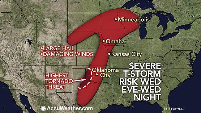
Long Term: A pretty active patter will set up across the nation heading into the weekend period. For tomorrow, a cold front will shift eastward across the central Plains with severe weather possible from the gulf coast all the way to Minnesota along the front. The highest coverage of storms should be near the area of low pressure across Iowa and Minnesota, but any storm that develops will be capable of producing very large hail and damaging winds. The front will sag southward and stall over the Ohio Valley by Friday into Saturday, with low chances of severe weather both days across the lower Mississippi Valley into the Tennessee valley. Storms could work their way into the Northeast this weekend as warmer air surges northward with this system. Looking farther out in time, it looks like some significantly warm air may affect all of the Northeast (widespread 80s and 90s) within the next two weeks. Get ready, summer is almost here!