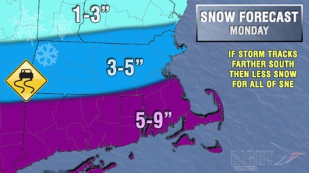
Disclaimer: This entire forecast is based on a storm track that is close enough to Southern New England to bring steady snow. Our main concern with the forecast is that the storm tracks farther south than currently projected, and takes the steadiest snow with it. In that case, Southern New England would be on the northern (lighter) edge of the storm.
We are looking at a storm that starts after midnight and before dawn on Monday. It will most likely be an issue for the Monday morning commute because the snow will have an easier time sticking to the pavement before dawn. Snow is likely all day Monday. The temperature will be in the dropping through the 20s and may reach the teens late in the day. With such cold temperatures, and snow already on the ground, the snow would continue to accumulate during the day. The storm will likely wind down by midnight, so it will not last quite as long as we originally expected. We’ll be watching the computer model trends and evolution of the system which is reaching California Friday morning. The storm is still three days away, and we will nail the forecast down over the weekend – hopefully on Saturday.

