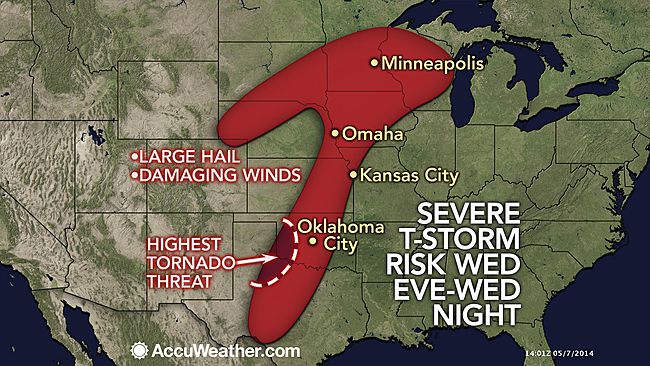
The big news about the run of the ECMWF is not the northeast snow… its the fact that it could even show that which should make folks understand that darn cold air is coming and its coming down the plains first. The “lock” for snow is the front range which should have the major late season event. in addition a big severe weather outbreak is on the way and its the kind of set up, with the clash of extremes, that could get the severe weather season alot of attention. Right now its remarkable again for how quiet its been but we have felt that late April and May would be more active than last year. Right now we are near the bottom for the date

The past 5 months have had the attempts at warming countered by major cold outbreaks. In a way what is looking like is about to happen is similar to the non blizzard weekend in early Feb….the trough this week underachieved relative to it major depth and the ECMWF 8-10 days before. However the source region of the air was not arctic.. this is and its coming full blast for the time of the year. But the tricky factor here is the fact we have 3 major upper features involved. At 72 hours we see the ECMWF with the first one coming out and this is the Denver snowstorm and starts the severe weather outbreak Sunday
The initial position is off the west coast and it rockets east, indicating the active southern stream is alive and kickng
.png)
by 72 hours that is already coming into the southern high plains
.png)
This is a big ticket severe weather outbreak Sunday into Monday as it lifts. Now here is where it starts getting real tricky as for the fate of the upstream areas. The short coming into the great basin came out of Alaska on the initial, so its from a different branch than what is obviously a fast southern branch. A look 48 hours later

has it dragging its heels a bit, but enough so cold air is charging out so much in front and the combination of it handing some energy off and the cold push way in front leads to the snow threat further east. However if the whole thing comes out and is lined up ( we have faced this problem before and some have come out, some dragged) then we look at even a bigger storm than the ECMWF has, and it has a heck of snow idea with this. But if we look at the 144 you see it does not come all the way in line and we wind up with a very strange look
.png)
Given the progression into the southwest of the next system, I would expect this to be further northeast along and with the northern branch, which ups the ante even more than what is one heck of a wild look to this model run. Look at the snowfall in 24 hour increments
48-72

Denver gets it Sunday

snow starts as you can see in the lakes as the trough pushes the cold air.. From Monday-Tuesday

But then the period where you saw that 120 feeding part of its energy northeast

Now one can imagine if all of that hooked up. The result would be more further west, but a heck an event anyway. The overall snow on the ECMWF through the entire period looks like this
.png)
The Canadian is more reasonable as the is the control run as they are weaker and further east.. both agree on the front range though!
Control
.png)
Control

Both of these are still impressive for this time of the year
one can see the JMA trying to phase this

This would certainly be the further west options back into the west side and into the Appalachians.
But there is alot on the table here and worth the watching..
Here is the forecast.. Headlines will be flying as far as the snow and cold Sunday into Monday with the severe weather too. And of course the usual suspects will be trying to use the same thing.. the WEATHER EVENT as evidence of the climate going wild, while the entire winter based on huge drivers seen before in past patterns ( and given the sun weakening the way it is…. look at this chart as far as that low geomagnetic we pointed out)

is somehow portrayed as just weather.
We live in a crazy world now. In any case for those of you that love crazy weather because you know its causes, you may be able to “enjoy” next week
Which is why I always say enjoy the weather, its the only weather you got


.png)
.png)

.png)
.gif)


.png)


.png)
.png)
.gif)


